This week is Earth Science Week, so it’s a fitting time to post about North Carolina’s geologic history and how the state’s geology influences the construction industry.
North Carolina’s diverse landscape, shaped by millions of years of tectonic activity, presents unique challenges for construction projects. From the rugged Blue Ridge Mountains to the soft soils of the Coastal Plain, understanding the state’s complex geology is essential for successful earthwork, foundation design, and infrastructure development. In this blog, we’ll explore how Summit’s geotechnical and drilling teams address these challenges to ensure safe, efficient construction across North Carolina.

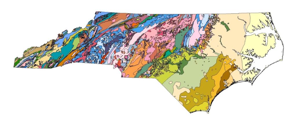
Geologic Map of North Carolina.
What Is Some of the Geological Makeup of North Carolina?
North Carolina’s three Physiographic Provinces– the Blue Ridge, Piedmont, and Coastal Plain– formed as a result of multiple continental collision events, rifting events, and subsequent erosion of the mountains formed from those collisions. The rocks in the Blue Ridge and Piedmont range from over a billion years old to about 200 million years old and are comprised of a diverse suite of sedimentary and volcanic rocks that were heavily metamorphosed during the tectonic collision events.
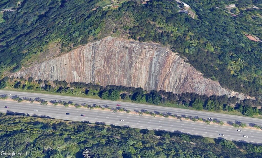
The originally horizontal layers, like what you see when driving through much of West Virginia, Tennessee, or Kentucky, were tilted very steeply or even vertically during the collisions that built the Appalachian Mountains. Igneous intrusions from magmas injected in-between the older sedimentary and volcanic layers during these mountain-building collisions, resulting in further variations in the bedrock types of the Southern Appalachians.

Horizontally Oriented Sedimentary Rock in Bluefield, West Virginia.

Vertically Oriented Metamorphic and Igneous Rock in North Carolina (Interstate 240 in Asheville, NC) .
Understanding North Carolina’s Triassic Basins and Coastal Plain
After the continental collisions that created the Appalachian Mountains, the continents then began to pull apart to create the Atlantic Ocean. During this continental rifting, small basins on the North American continent formed along with the main basin that created the Atlantic Ocean. These small basins, often called “Triassic Basins” since they formed in the Triassic Period, became inland lakes that filled with sediment from erosion of the adjacent highlands. The sedimentary rocks that formed in these small basins are younger than the adjacent rocks of the Piedmont and Mountains, only about 200-250 million years old. The Triassic Basins in North Carolina can be found in Durham, Sanford, Wadesboro, Eden, and Yadkinville. These basins hold small deposits of fossil fuels such as natural gas and coal. As the Atlantic Ocean continued to open, rivers deposited sediments from the weathering of the Appalachian Mountains along the coast, creating the Coastal Plain.
Construction Issues in North Carolina’s Piedmont and Blue Ridge Regions
North Carolina’s geologic setting and complex history can create challenges for the construction industry during earthwork and foundation construction, challenges which Summit’s Geotechnical, Drilling, and Construction Materials Testing departments help to identify and alleviate.
The iron-rich volcanic rocks of North Carolina’s Mountains and Piedmont tend to weather deeply below the surface and produce Elastic Silts and Fat Clays, the classic “Red Clay” common in the area. These soil types have a low bearing capacity at elevated moistures and can cause major settlement issues. Therefore, they must be properly identified and removed or mitigated during construction.
Summit’s Geotechnical and Drilling teams identify these soils before the start of construction, and the CMT technicians and engineers ensure they are properly managed by contractors during construction. Our CMT technicians are especially useful in monitoring earthwork for NCDOT projects, which is critical to their long-term viability in the region.
Geotechnical Issues in North Carolina’s Coastal Plain and Triassic Basins
North Carolina’s younger sedimentary settings can give geotechnical engineers different challenges. When constructing in the Coastal Plain (generally around and east of Interstate 95), engineers must account for significant settlement from thick layers of soft, saturated clay when providing recommendations and designs. Limestone layers, typically only found in the Wilmington area, can cause engineers headaches during bridge design due to their ability to halt the driving of piles through otherwise penetrable sediments.
In the Piedmont, sedimentary bedrock within the Triassic Basins is prone to slaking, a process where solid bedrock will rapidly degrade to highly plastic silts and clays when exposed to moisture. This causes significant complications during grading for roads and buildings, as the seemingly stable cobbles and boulders making up a fill slopes will rapidly degrade to soil, resulting in potential settlement issues and compromising structural integrity.
Summit’s Expertise in Tackling North Carolina’s Unique Geologic Challenges
North Carolina’s intricate geologic history presents a wide range of engineering challenges that can significantly impact construction projects. From unstable soils to shallow bedrock and shifting sedimentary layers, understanding these subsurface conditions is crucial for project success. Summit’s team of geotechnical engineers, geologists, drillers, and technicians are experts in identifying and addressing these geological complexities, ensuring that potential issues are mitigated before they become costly problems. With their comprehensive approach, Summit provides reliable solutions that help keep projects on schedule, within budget, and structurally sound, no matter the geological obstacles.
