-

anemptytextlline
anemptytextlline
anemptytextlline
anemptytextlline
anemptytextlline
-

anemptytextlline
anemptytextlline
anemptytextlline
anemptytextlline
anemptytextlline
Chatham County, NC -

anemptytextlline
anemptytextlline
anemptytextlline
anemptytextlline
anemptytextlline
Raleigh, NC -

anemptytextlline
anemptytextlline
anemptytextlline
anemptytextlline
anemptytextlline
Mebane, NC -

anemptytextlline
anemptytextlline
anemptytextlline
anemptytextlline
anemptytextlline
Raleigh, NC -

anemptytextlline
anemptytextlline
anemptytextlline
anemptytextlline
anemptytextlline
Wake County, NC -

anemptytextlline
anemptytextlline
anemptytextlline
anemptytextlline
anemptytextlline
Raleigh, NC -

anemptytextlline
anemptytextlline
anemptytextlline
anemptytextlline
anemptytextlline
Orange County, NC -

anemptytextlline
anemptytextlline
anemptytextlline
anemptytextlline
anemptytextlline
Hillsborough, NC -

anemptytextlline
anemptytextlline
anemptytextlline
anemptytextlline
anemptytextlline
Durham, NC -

anemptytextlline
anemptytextlline
anemptytextlline
anemptytextlline
anemptytextlline
Angier, NC -

anemptytextlline
anemptytextlline
anemptytextlline
anemptytextlline
anemptytextlline
Durham, NC -

anemptytextlline
anemptytextlline
anemptytextlline
anemptytextlline
anemptytextlline
Raleigh, NC -
")
anemptytextlline
anemptytextlline
anemptytextlline
anemptytextlline
anemptytextlline
Edgecombe County, NC -

anemptytextlline
anemptytextlline
anemptytextlline
anemptytextlline
anemptytextlline
Cumberland County, NC -

anemptytextlline
anemptytextlline
anemptytextlline
anemptytextlline
anemptytextlline
Hillsborough, NC -
")
anemptytextlline
anemptytextlline
anemptytextlline
anemptytextlline
anemptytextlline
Orange County, NC -

anemptytextlline
anemptytextlline
anemptytextlline
anemptytextlline
anemptytextlline
Orange County, NC -

anemptytextlline
anemptytextlline
anemptytextlline
anemptytextlline
anemptytextlline
Durham, NC -

anemptytextlline
anemptytextlline
anemptytextlline
anemptytextlline
anemptytextlline
Creedmoor, NC -

anemptytextlline
anemptytextlline
anemptytextlline
anemptytextlline
anemptytextlline
Hillsborough, NC -

anemptytextlline
anemptytextlline
anemptytextlline
anemptytextlline
anemptytextlline
Hillsborough Historic District, NC -

anemptytextlline
anemptytextlline
anemptytextlline
anemptytextlline
anemptytextlline
Hillsborough, NC -

anemptytextlline
anemptytextlline
anemptytextlline
anemptytextlline
anemptytextlline
Statewide, NC

Staking out the foundations for our communities.
Surveying has been a core service of Summit since our firm’s very inception. This long history enhances our unique perspective on surveying and the impact it has on other disciplines, allowing us to work cohesively with the other service departments to deliver comprehensive, full-service projects to our clients. The Summit Geomatics department provides surveying services tailored to private and public clients for a variety of projects in North Carolina, South Carolina, Virginia, and Georgia. Our advanced technical capabilities combined with decades of experience positions us to collect, analyze, and interpret survey data efficiently so that we can meet even the most aggressive schedule.
We bring our best to every project to ensure that our clients have the most accurate and up-to-date data to work with. That’s why Summit’s Survey and Geomatics team utilizes state-of-the-art equipment that allows us to collect the most accurate information and high-definition surveys. We also provide survey verification services utilizing the latest technology, so that we can verify contractor-performed construction staking is thorough and accurate.
Our services include wet utilities, drainage structures, pipe culverts, culvert and wall structures, bridges, and sign S-dimensions. We also verify roadway staking including slope stakes, fine grades, blue tops, and curb and gutter. We take pride in knowing that the validating information we provide goes on to become the foundation for projects that improve our communities.
the Summit Survey and Geomatics Overview Blog features descriptions and visual examples of our many modern services, including a comprehensive look at the types of surveys we conduct. Check it out!
Capabilities
- Boundary Surveys
- Topographic Surveys
- ALTA/NSPS Surveys
- Engineering Surveys
- As-Built Surveys
- Route Location/Corridor Surveys
- GPS/GNSS Surveys
- Aerial (Drone) Surveys
- Stream Mitigation/Restoration Surveys
- Subdivision Plats
- Recombination Plats
- Construction Surveys
- Site Plans/Plot Plans
- 3D-Laser Scanning
- Lighting (Photometric) Surveys
- Elevation Certificates
Featured Project
Discovery Charter School
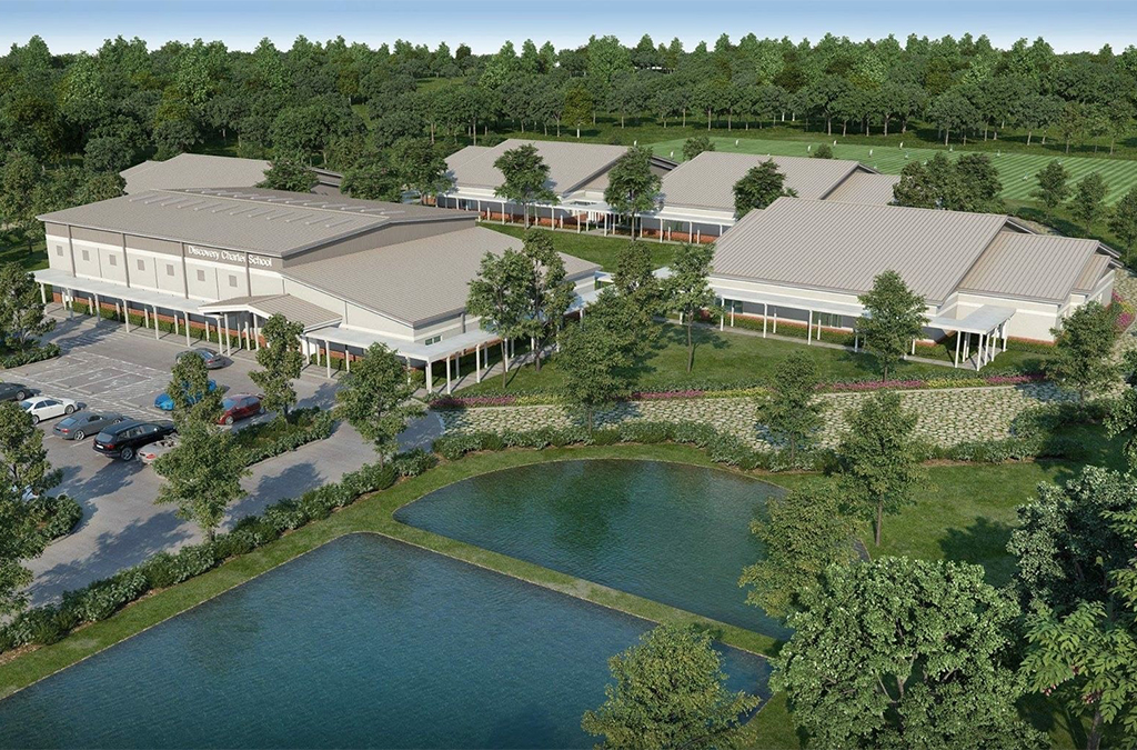
Summit’s Surveying and Geomatics, Land Development, and Construction Materials Testing departments all worked together to provide site design, permitting, and other vital services for the development and construction of the Discovery Charter School in Durham County, NC.
The facility consists of four 10,500 square foot classroom buildings, and one 12,000 square-foot gymnasium, all connected by a large network of sidewalks. This 49-acre site also includes a soccer field, 78 parking spaces, and areas for bicycle storage. There was no public water or sewer serving the area, so there was also a six-acre septic system installed on the property.

Our Equipment
How We Use a 3D Laser Scanner to Benefit Our Clients
By using the Leica P-40 Terrestrial Laser Scanner on a project, our team is able to scan an entire project area or building and obtain accurate measurements.
Service Contact

Valerie Welbourn
Survey Department Manager