-

anemptytextlline
anemptytextlline
anemptytextlline
anemptytextlline
anemptytextlline
Raleigh, NC -

anemptytextlline
anemptytextlline
anemptytextlline
anemptytextlline
anemptytextlline
Multiple Locations, NC -

anemptytextlline
anemptytextlline
anemptytextlline
anemptytextlline
anemptytextlline
Statewide, NC -

anemptytextlline
anemptytextlline
anemptytextlline
anemptytextlline
anemptytextlline
Hillsborough, NC -

anemptytextlline
anemptytextlline
anemptytextlline
anemptytextlline
anemptytextlline
Statewide, NC -

anemptytextlline
anemptytextlline
anemptytextlline
anemptytextlline
anemptytextlline
Mecklenburg and Union Counties, NC -

anemptytextlline
anemptytextlline
anemptytextlline
anemptytextlline
anemptytextlline
Statewide, NC

Paving the way for a more connected future.
Our Transportation Maintenance Management team understands how vital transportation infrastructure is for a community’s well-being. Our communities rely on the roads that bind us, and we strive to keep that infrastructure healthy and functional. We approach each problem or challenge with an innovative and responsive mindset, developing solutions to keep our infrastructure functional and safe. Our encompassing approach to maintenance management, including our advanced inspection, monitoring, and reporting capabilities, accomplishes this goal.
Our team utilizes the latest technology, like AI and ArcGIS, to ensure that all infrastructure is safe, secure, and well-maintained.
We know the transportation infrastructure must be appropriately maintained to serve our communities, and maintenance management is the primary way to make that goal a reality. By partnering with us, our clients can create the resilient, adaptive infrastructure our modern world needs to thrive.
Capabilities
- Pavement Condition Assessments for Roadways and Parking Lots
- Geographic Information Systems (GIS)
- Asset Inventory
- Asset Assessment
- Emergency Response
- Roadside Systems
- Drainage Systems
- Sidewalk and Curb Ramp Assessments
- Stormwater Inventory and Assessment
- Contract Development
- Contract Administration and Inspection
Maintenance Management Services
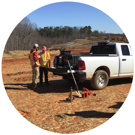
Our Maintenance Management Department is staffed by a team of former NCDOT and municipal roadway engineers and inspectors, all of whom possess extensive experience in asphalt and concrete repair and preservation practices.
We specialize in GIS mapping, roadway pavement condition surveys, parking lot assessments, and CCTV pipe camera inspections. In addition, our administrative and technician staff develop construction contracts, prepare quantity takeoffs, and provide project oversight and inspection services once construction is underway.
Using parameters established by the client as a guideline, our inspectors determine the quality of each road or parking lot and assign a Pavement Condition Rating (PCR) ranging from “very good” to “very poor.” The PCR score corresponds to the level of pavement defects identified in each established segment, provides prioritization for maintenance, resurfacing, and rehabilitation projects, and provides cost-effective treatment recommendations to extend the life of the pavement.
Preservation of the existing roadway infrastructure is ideal, with repaving or replacing an asset being a last resort. By providing inspectors with a map of corresponding colors and identified defects, we can quickly identify which routes to prioritize and develop an effective strategy to address pavement defects and maximize pavement life.
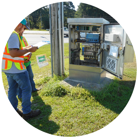
Asset inventory is a specialized service that assesses the condition of various infrastructure installations within a particular area. Utilizing GPS and GIS mapping technology, our inspectors can locate and conduct comprehensive assessment surveys of assets within a client’s specified range.
Summit maintains accurate, up-to-date records of these assets, which helps us develop a strategic schedule for timely upgrades, repairs, and replacements. If an asset requires any work, our maintenance management team can establish cost estimates, develop contracts, and provide contract administration and inspection services.
Asset inventory and assessment is a specialized service that provides the geographic location of an asset and assesses the condition based on specific criterion. Utilizing GPS and GIS mapping technology, our inspectors can locate and conduct comprehensive assessment surveys of assets within a client’s specified range.
Summit maintains accurate, up-to-date records of these assets, which helps us develop a strategic schedule for timely upgrades, repairs, and replacements. If an asset requires any work, our maintenance management team can establish cost estimates, provide contract development, and provide contract administration and inspection services.
The primary element of the Summit team’s approach is our experienced team of Disaster Response personnel. Summit’s key personnel have extensive knowledge of the NCDOT disaster recovery process and FEMA and FHWA requirements. The Summit team is one of the firms on the NCDOT Disaster Recovery Assistance Contract. Our team proactively met with each Division we were assigned to support and worked with Division personnel to develop a disaster recovery response plan specific to each Division. We have developed and conducted training for Summit Team members related to Survey123, SAP, truck certification, debris monitoring, and site-specific assessment and documentation. The Summit team will extend this same approach to municipal, county, and state clients.
The initial assessment is one of the key elements of disaster response immediately following an event. Summit Team members will deploy immediately to assist the client with the initial assessment to determine whether declaration criteria will be met. The Summit Team, utilizing Summit-owned iPads and mobile technology capable of GPS technology and Survey123, can locate, document, and estimate debris and site-specific locations as part of the initial assessment.
As a result of the initial assessment and working with the client, the Summit Team can develop emergency contracts for debris removal and site-specific damage. The Summit team will coordinate with the client to create a debris removal plan for the damage associated within the assigned area. Summit Debris Monitor supervisors will meet with the Debris Hauling contractor, certify their equipment, and ensure they operate safely and within FEMA guidelines throughout the debris removal operation. Summit team members are trained as more than load ticket writers. We are experienced with Cubic Yard and Tonnage contracts and the pros and cons of each. Monitors will be keenly aware of partial, wet, and non-qualifying debris. We will ensure that documentation and work accomplished will reflect the highest reimbursement possible through FEMA audit standards.
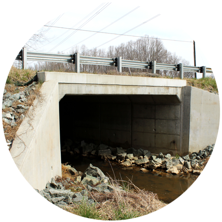
For site-specific locations, the Summit team can manage the complete project. This includes providing surveys, hydraulic analysis, plan design, emergency contracts, contract administration, inspection, and required documentation. The Summit team is familiar with FEMA and FHWA documentation required for large and small projects, from minor shoulder washouts to multi-barrel pipe replacements.
Each segment of the sidewalk surveyed is marked by a color-coded line, with green indicating a sidewalk section that does not require attention and red representing sections that need immediate attention. Click on a segment to learn more about the pavement quality, with supplementary pictures attached.
The Hillsborough Sidewalk Rating map is a community-oriented effort to address local concerns about the usability of their paved pedestrian spaces. Each instance of a sidewalk on this map is recorded using an inspector who walked the premises, taking pictures of any faults, damages, or defects in the pavement. As our goal is to improve accessibility and ease of use, significant consideration was given to complications hindering a pedestrian’s ability to safely and easily access the sidewalk. These steps, alongside ensuring that curb ramps are usable and in good repair, are critically necessary to ensure that Hillsborough’s sidewalks are ADA-compliant.
The pavement condition was not the only aspect recorded in this initiative. Other factors, such as overgrown foliage, contributed to the issues faced by pedestrians in the community. Inspectors encounter complications the same way an average pedestrian might by manually reviewing the walkways.
Our inspection process is assisted by DeepWalk, a cutting-edge technology that can be held in the palm of your hand. Our inspectors start by recording sections of pavement using their iPhone cameras. DeepWalk then uses LiDAR to analyze these sections and create points on a data map for later analysis. The detail captured by DeepWalk creates intricate images that can show exactly where issues are within the sidewalk sections. This data can be added to our GIS maps, providing a broader understanding of any issues present in a section of pavement.
Our inspectors analyzed curbs, gutters, pipes, ditches, catch basins, and more to ensure the functionality and safety of these assets. Problematic aspects include blockages, erosion, damaged or missing sections, and anything else that might impact the functionality of the utilities. We utilize Bad Elf GPS surveying technology to analyze more complex utility assets, such as drop-inlets; the high-accuracy vertical collision capabilities provided by Bad Elf GPS surveying tech allow us to obtain precise measurements for slopes so that water utilities can be safely and accurately installed or maintained.
When a utility is impaired, it can create dangerous conditions during heavy rains, natural disasters, and other events. Water can flood streets, sidewalks, and even homes when drainage is blocked or damaged. Color-coordination on the map brings visual attention to these areas of concern. Repair technicians can then identify problem “problem areas” to create effective treatment plans that enable them to safely and quickly address impaired assets
Our team will work with the client to develop paving priorities based on factors that include but are not limited to:
- Current pavement condition survey evaluations
- Development of clustered contracts for designated communities
- Citizen input and community impact with priority optimized as viewed through an equity lens
- Historical and future paving planning to develop a comprehensive Pavement Management Program
Our team will utilize the information and routes designated in the paving priority and develop contract bid quantities, providing detailed contract line items and engineer estimates. Our team will develop all contract bid documents for let to include vicinity maps, typical sections, and standard and special provisions.
Our team will participate in all pre-bid meetings with contractors, assisting in answering any questions related to the bid document. We will assist in evaluating responsible bids compared to the engineer’s estimates and recommend awards.
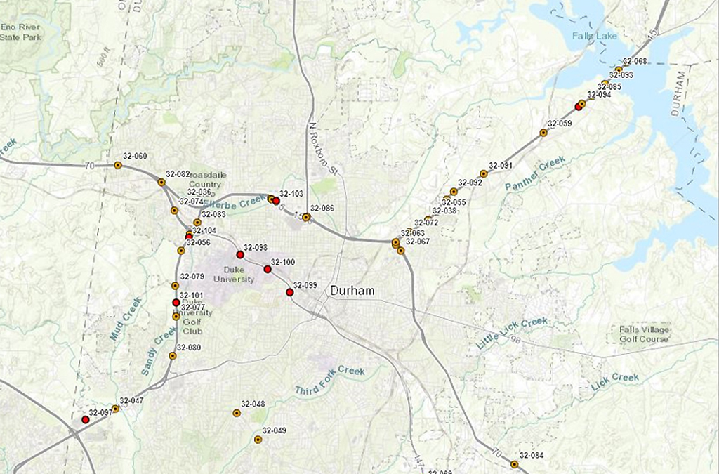
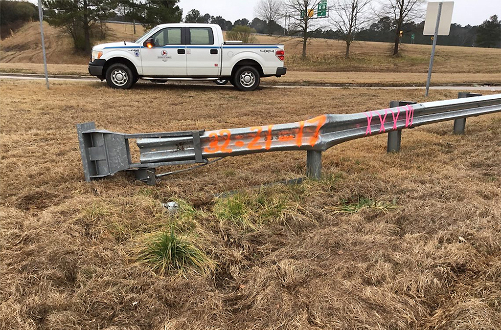
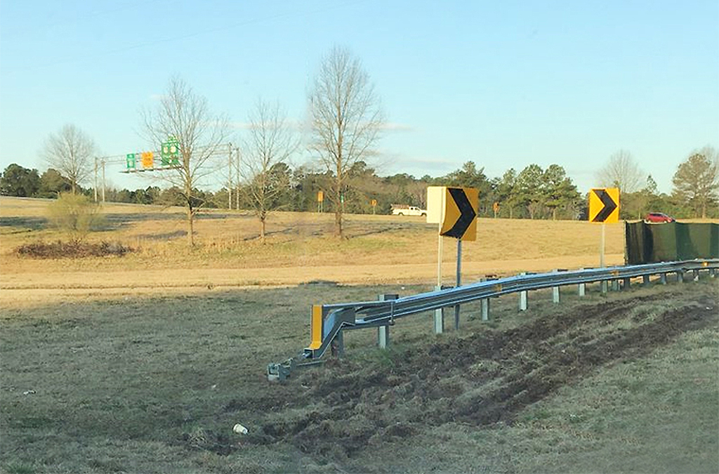
Featured Project
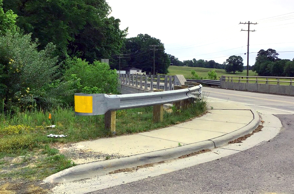
NCDOT Guardrail Inspection and Repair
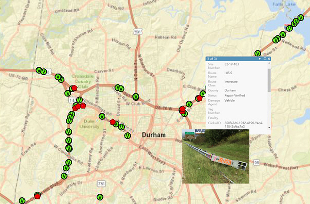
We provided GIS-based guardrail damage and reporting collection for multiple counties, where we utilized ArcGIS to create and maintain data used for the planning and repair of guardrails. Summit’s GIS team, within the Maintenance Management Department, developed the ArcGIS Collector to collect and host the data.
Our team conducted weekly assessments of multiple NCDOT routes to identify damaged and non-compliant sections. Included in the dataset are pictures, the route name and class, exact GPS coordinates, and a cost and materials estimate for the repair which allowed the contractor to mobilize quicker and more efficiently. Once the repair is completed at a specific site, the contractor edited the status as repair verified.
Understanding Assets
Asset inventory is a specialized service that assesses the condition of various infrastructure installations within a particular area. Utilizing GPS and GIS mapping technology, our inspectors can locate and conduct comprehensive assessment surveys of assets within a client’s specified range.
Summit maintains accurate, up-to-date records of these assets, which helps us develop a strategic schedule for timely upgrades, repairs, and replacements. If an asset requires any work, our maintenance management team can establish cost estimates and contract the work based on the estimates provided.
Contract Development and Project Inspection
Our Contracts Team develops detailed project manuals for potential bidders, using field data, GIS maps, and in-depth reports. These manuals include general and special provisions, project details, and typicals that clearly define the project scope. We handle all pre-bid activities, Q&A sessions, bid openings, and preconstruction meetings, ensuring a smooth process for both clients and contractors. By providing accurate material quantities, our team helps clients save money, avoid unnecessary allowances, and achieve realistic budgeting and planning.
Our Inspection Team is on-site throughout the project, working closely with contractors to ensure all work meets contract specifications. They test materials such as asphalt, concrete, ABC, and sub-surface soils as needed, providing quality assurance at every stage. Daily reports with photos keep clients informed of progress, while our project managers oversee final closeout activities, ensuring all punch list items are addressed before project acceptance.
Summit’s integrated approach combines meticulous planning, hands-on inspection, and proactive project management, delivering projects that meet both budget and quality expectations.
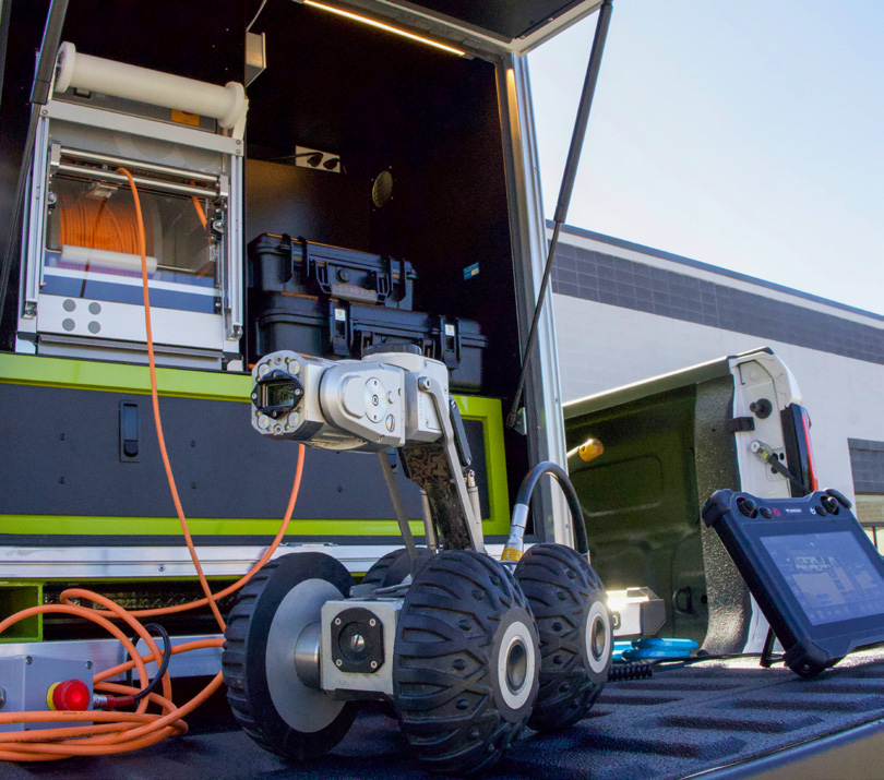
Closed Circuit TV (CCTV) Pipe Inspection Services

Summit provides professional CCTV inspection services to assess and document stormwater piping and related structures. Our team mobilizes specialized equipment and trained personnel to the site to inspect accessible pipes, catch basins, manholes, and junction boxes. During inspections, we carefully document defects such as joint separation, cracks, root intrusions, blockages, sediment accumulation, and other potential issues that could affect system performance.
Our inspections are supported by comprehensive reports that include video footage, detailed pipe locations and sizes, and all observed deficiencies. For hidden junctions or bends not visible from above ground, we provide accurate locating and marking to ensure a complete understanding of the system. Where applicable, we offer recommendations for corrective actions, helping clients prioritize repairs and maintenance to prevent future issues.

Service Contact

Jonathan Arnold, PE
Transportation Maintenance Manager